A cemetery map only becomes useful when it connects to the work your team needs to do. That means linking plots to inspections, memorial jobs, permits, tasks and a schedule that people can trust. If you manage a council cemetery, a parish churchyard or a multi-site estate, the most effective cemetery mapping software is the one that makes location information usable in the field and in the office, without adding admin.
SAMM focuses on this practical connection. It brings two modules together so locations are not just dots on a plan but part of a clear workflow. SAMM Safety handles inspections, records and reporting. SAMM Retail manages memorial jobs from enquiry to install with permits, locations and scheduling. Both are built by bereavement-industry professionals.
What good cemetery mapping should deliver
When people ask for cemetery mapping, they usually need five outcomes.
- Find the right plot quickly. Searchable records tied to inspection history, documents and photos so answers are instant at the desk and on site.
- See location in the workflow. Orders, permits and jobs linked to plots so dates reflect reality and teams turn up in the right place.
- Plan and track work. Routes, diaries and follow-ups for inspections, with dashboards that show status and priorities.
- Work offline when needed. Tablets that capture outcomes and photos without signal, with secure sync later.
- Use a map where it helps. Visual mapping integrated with the same records and modules your team already uses.
How SAMM supports mapping in practice
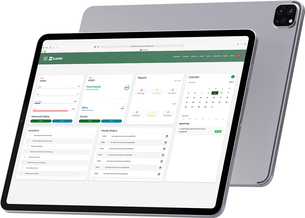
Location-linked records and jobs
In SAMM Retail every order carries its grave location. You can track permit submission and return dates, then schedule the fitting and allocate the right team in a shared calendar. This keeps location, readiness and capacity in one picture.
In SAMM Safety your searchable grave records sit alongside inspection history, documents and photos. Outcomes are visible immediately, which makes it easier to prioritise work by section or row.
Field-ready capture with offline mode
Patchy signal is common in cemeteries. Inspectors use Android or iOS tablets to capture outcomes, photos and notes offline and sync once back online. Managers see results in the secure cloud, ready for reporting and action.
Digital maps through trusted partners
When you need a visual map, SAMM integrates with digital mapping partners, including Pear Technology, so plotted sections align with the live inspection and memorial workflows. This reduces rework and helps teams find the right place first time.
Explore modules: SAMM Safety and SAMM Retail.
Feature checklist for evaluating cemetery mapping software
Use this to shape your brief and compare vendors.
- Record linkage that ties applicants, deceased details, documents and photos to each plot.
- Permit and location management within the same workflow as orders and scheduling.
- Shared calendar and tasks so capacity is clear and clashes are avoided.
- Inspection routes and follow-ups with an audit trail to a safe conclusion.
- Offline tablet mode with secure cloud sync for low-signal sites.
- Partner mapping integration that connects your visual map to the same records and modules.
- Onboarding and training to import existing data and match your structure.
Common workflows that depend on mapping
1) Find a plot and answer a resident quickly
Staff search by name or section, open the record and see inspection history, documents and photos. The exact location is clear and the status is current.
2) Book a fitting at the right location
In SAMM Retail, the order is linked to a plot and permit dates are visible. You book a fitting date, assign the team in the shared calendar and avoid clashes across branches.
3) Prioritise remedial work by area
In SAMM Safety, route planning and a shared diary help you focus inspections or follow-ups in a section. Photos and outcomes appear in the cloud for quick reporting and action.
Why cloud plus offline matters for mapping
Maps are only useful when data is captured consistently. With SAMM, inspectors can work without signal, then sync automatically. Managers get a full history with photos, letters and reports so decisions are evidenced and easy to share.
Data import, onboarding and support
Most teams have legacy plans and spreadsheets. SAMM’s onboarding imports existing grave records, helps with cleaning and sets up a structure that matches how your authority works. Training and help desk support are included, so teams get confident quickly. Pricing is tailored to size and usage and includes onboarding, training, support, licensing, software and data storage.
Ready to connect mapping to real work
See how location linking, partner mapping, inspections, permits and scheduling come together in a single view. A short walkthrough can be tailored to your sites and processes.
FAQs
Does SAMM include a digital map out of the box SAMM focuses on operational workflows with location-linked records and jobs. When you need a visual map, SAMM integrates with digital mapping partners such as Pear Technology so your map aligns with inspections and memorial management.
Can we work offline on site Yes. Android and iOS offline mode lets teams capture inspections, photos and notes without a signal and sync later to the secure cloud.
Can we tie memorial orders and permits to plots Yes. In SAMM Retail every order carries its grave location, permit submission and return dates, with a shared calendar for scheduling.
Can SAMM import our records and align them to locations Yes. The onboarding team imports data and helps clean it so you start with accurate records that reflect how you work.
How does pricing work Pricing is tailored to your size and usage and includes onboarding, training, support, licensing, software and data storage.